Arctic Sea Ice Shrinks to Its 2026 Minimum
Story summary
Satellite records show Arctic sea ice covering less of the ocean in both winter and summer.
📌 Key Highlights & Takeaways
- Satellite records show Arctic sea ice covering less of the ocean in both winter and summer.
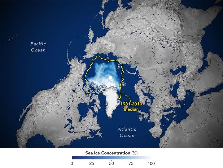
All Topics Atmosphere Land Heat & Radiation Life on Earth Human Dimensions Natural Events Oceans Remote Sensing Technology Snow & Ice Water More Content Collections Global Maps World of Change Articles Earth Matters Blog Blue Marble: Next Generation EO Kids Mission: Biomes About About Us Subscribe 🛜 RSS Contact Us Search Arctic sea ice reaches its annual minimum extent on September 12, 2026, tying several past years for the 10th-lowest minimum in the satellite record. NASA Earth Observatory/Michala Garrison This story is an update to the Arctic sea ice feature in our World of Change series, which tracks long-term change on Earth’s surface through satellite imagery.
A layer of frozen seawater caps the Arctic Ocean. This sea ice grows through the long polar winter, usually peaking in March, then melts through the summer to its annual low in September. It is a natural fluctuation that has persisted for millennia. But satellite records show the ice now covers less of the Arctic Ocean at its annual maximum and minimum than it did a few decades ago.
Sea ice in 2026 reached its annual minimum extent on September 12 (above), when it covered an estimated 4.6 million square kilometers (1.78 million square miles), according to NASA and the National Snow and Ice Data Center (NSIDC). That ties 2008, 2010, and 2025 for the 10th-lowest minimum in the satellite record.
The maps below pair each September since 1990 (left), around the ice’s annual minimum, with the following March (right), near its annual maximum, through March 2026.
Scientists have used satellites to observe the annual growth and retreat of Arctic sea ice continuously since late 1978. While sea ice extent has declined overall during that time, the downward trend steepened in the 2000s and set off a run of record and near-record lows. Each of the past 20 summers, from 2007 through 2026, ranks among the 20 lowest minimum extents in the satellite record. The lowest occurred in September 2012.
More recently, the September sea ice extent has been relatively steady. Weather can make a big difference in how much ice melts from one summer to the next. For example, over the past decade, increased cloud cover has prevented sunlight from accelerating the melt , according to NASA scientists . Despite this recent plateau, the summer minimum remains well below the long-term average.
Across the Arctic, the ice that remains is younger and thinner . Observations show a decline in multiyear ice—that which survives at least one melt season—leaving an Arctic dominated by thinner first-year ice . Winter ice is also shrinking. The March 2026 maximum statistically tied the 2025 maximum for the lowest in the satellite record.
Cycles of natural variability such as the Arctic Oscillation are known to play a role in Arctic sea ice extent, but the decline observed throughout the satellite record cannot be explained by natural variability alone. Natural variability and rising global temperatures have worked together to melt greater amounts of Arctic sea ice. Scientists have projected an essentially ice-free Arctic could occur at least once before the middle of the 21st century.
Cryptographic Security & Key Generator
Generate entropy-tested high-security keys and encryption-grade tokens.
Source: NASA.
Read the full story at the original source ↗
For questions: mrsmithcons@gmail.com.
❓ Frequently Asked Questions (Satellite Datasets Briefing)
What orbital telemetry or sensor data corroborates this Satellite Datasets discovery?
Multi-spectral satellite imagery, radar altimetry, and space agency observational feeds provide calibrated observational data confirming the parameters of this event.
How does this observation impact current aerospace and geospatial modeling?
The recorded metrics refine atmospheric correction algorithms and orbital ephemeris models, enabling higher resolution tracking and trajectory accuracy.
When is the next telemetry downlink or public briefing scheduled?
Real-time space agency mission updates and satellite overpass data are ingested continuously through FreeSky GeoData tracking desks.
🗺️ Complete Satellite Dataset Pack & Processing Scripts
Geotiff files, QGIS project templates, and Python raster analysis scripts.
⚡ Download Geo Pack ➔More from FreeSky GeoData
 🤖 WinBar AI
Weitere Informationen zu Smart Betting AI 2026
Aktuelle Berichterstattung von Clarin.com: Znajdź najlepsze Smart Betting AI 2026. Unser News Desk verfolgt la...
 ☁️ FreeSky Cloud
All the numbers: Amazon Prime Day 2026 powered by AWS
Amazon Prime Day 2026 was exclusively for Prime members and ran June 23–26, 2026 with millions of deals across...
 🔭 FreeSky Cosmos
APOD: 2026 October 7 – Supernova Remnant Pa 30
APOD Science APOD APOD: 2026 October 7 –… Today’s APOD Archive Submissions Index Search Calendar RSS Education...
OpenAI Unveils Watermark
OpenAI is introducing textGrain, an invisible watermark for AI-generated text, for EU ChatGPT and Codex users....