Uncovering the Valleys Hidden Below Greenland’s Ice
Story summary
A new map of the terrain beneath the Greenland Ice Sheet links hundreds of valleys that previous maps missed or left fragmented.
📌 Key Highlights & Takeaways
- A new map of the terrain beneath the Greenland Ice Sheet links hundreds of valleys that previous maps missed or left fragmented.
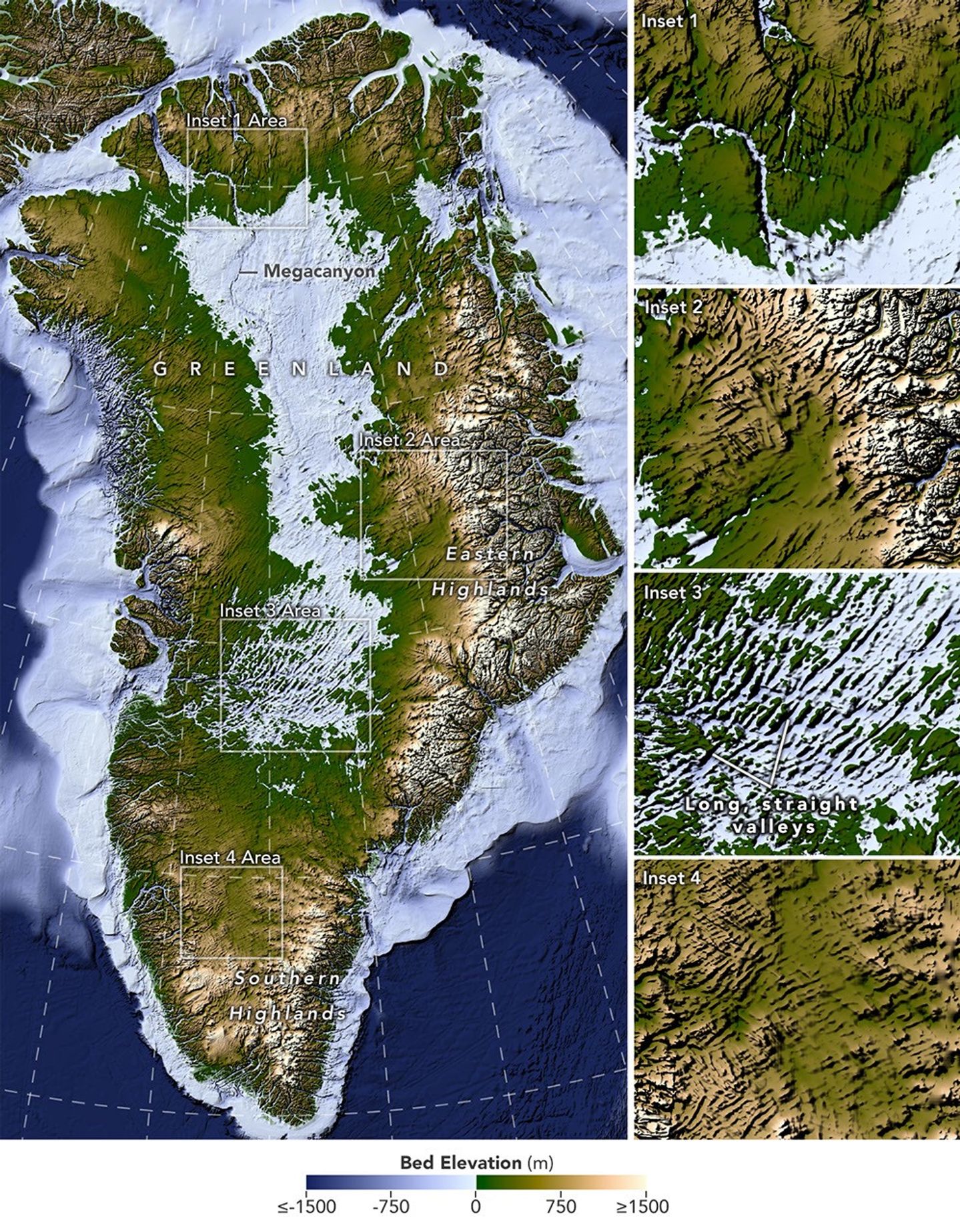
All Topics Atmosphere Land Heat & Radiation Life on Earth Human Dimensions Natural Events Oceans Remote Sensing Technology Snow & Ice Water More Content Collections Global Maps World of Change Articles Earth Matters Blog Blue Marble: Next Generation EO Kids Mission: Biomes About About Us Subscribe 🛜 RSS Contact Us Search A newly developed method for mapping the bedrock beneath Greenland’s ice sheet reveals the island’s hidden topography. Among the most striking finds are long, straight valleys in the west-central region, some mapped for the first time and others extending farther inland than previously known (inset 3). NASA Earth Observatory/Lauren Dauphin, based on data from Chartrand et al . Greenland is capped with a vast ice sheet that spans 1.7 million square kilometers (656,000 square miles) and measures more than 3 kilometers (1.9 miles) at its thickest point. Below all this ice lies a landscape human eyes have never seen directly. But a newly developed method for mapping this hidden bedrock has produced the most detailed and accurate view of it yet.
The new map reveals an expansive network of valleys carved into the surface beneath the Greenland Ice Sheet. Many of the features formed well before most of the ice above them existed, offering new context for the island’s geologic history—and potentially helping scientists refine projections of the ice sheet’s future. Scientists described the newly mapped valleys in a NASA-led paper published in Geophysical Research Letters .
The map, shown above, was derived from a method called Ice Flow Perturbation Analysis. As ice flows over a valley or ridge, the topography leaves a faint signature on the ice surface. Satellites map the ice surface in fine detail, and scientists can use these subtle bumps and dips to infer the shape of the landscape buried below. The work aims to improve future versions of BedMachine Greenland , a high-resolution dataset of the terrain beneath the ice sheet.
Using the technique, researchers manually mapped 1,943 subglacial valleys beneath the Greenland Ice Sheet, about a third of which are newly identified. About half of the valleys included in BedMachine Greenland, primarily near the ice sheet’s edge, are now known to extend farther inland than that map indicates, in some cases by hundreds of kilometers.
Some aspects of the new map align with the current understanding of how Greenland’s landscapes formed. For instance, many of the valleys appear to begin in the southern and eastern highlands, where the ice sheet is thought to have first formed. Near the eastern highlands, the map reveals a mountain range beneath the ice, with interconnected valleys and relief that increases toward the coast. These alpine-style landforms may have survived under the ice since at least the Pliocene.
Other aspects of the topography are more puzzling. The analysis indicates numerous valleys, especially in the west-central region, that are long, straight, and consistently aligned in a southwest-northeast direction. This orientation suggests a tectonic influence, generating preferential pathways along which water could flow and valleys could form. “That’s a riddle to us,” said Joe MacGregor, a NASA cryospheric scientist and co-author of the study. “Greenland is justifiably usually treated as a rigid block of old rock that is simply translated as needed to accommodate the motion and interactions of other tectonic plates.”
Separately, the angles at which the valleys branch offer another insight into their origin. Their relatively wide branching angles suggest that surface water didn’t act alone; instead, a widespread groundwater network—seeping upward and eroding the surrounding rock—likely helped carve the valleys before the ice sheet formed.
Mapping these valleys matters for understanding the ice sheet, which has continued to dramatically reshape the landscape. Ice flow concentrates in valleys, where it forms glaciers that eventually calve into fjords at the periphery of the ice sheet. This creates a reinforcing cycle: ice funneling through a valley gets thicker, thicker ice flows faster, and faster flow carves the valley even deeper.
Cryptographic Security & Key Generator
Generate entropy-tested high-security keys and encryption-grade tokens.
Source: NASA.
Read the full story at the original source ↗
For questions: mrsmithcons@gmail.com.
🗺️ Complete Satellite Dataset Pack & Processing Scripts
Geotiff files, QGIS project templates, and Python raster analysis scripts.
⚡ Download Geo Pack ➔More from FreeSky GeoData

Apple’s new CEO on what comes after iPhone Duo | Inside John Ternus' first week
We sit down for an exclusive chat at Apple Park with new CEO John Ternus and SVP of Worldwide Marketing Greg J...
 🤖 WinBar AI
Best AI Model Odds – The Top Markets and Outcomes
Breaking coverage reported by Casino.org: Best AI Model Odds – The Top Markets and Outcomes. Our news desk tra...
 ☁️ FreeSky Cloud
Guia de práticas recomendadas para personalizar modelos Gemini via Reinforcement Learning (RL)
A aprendizagem por reforço (RL) tem sido uma pedra angular do pós-treinamento LLM moderno, mas exige grandes c...
Green Hulk vs Red Hulk City Destruction | Epic Aerial Drone Cinematic 4K
Cinematic aerial drone shot in stunning 4K 24fps. High above a sprawling modern city at golden hour, the camer...